
Bruce’s Weather Forecast - VanIsle360 2025 Start
This is absolutely one of the best and most challenging long-distance races you can do in the Pacific Northwest. The Race Committee, the folks in the different ports along the way, and the camaraderie you develop with your fellow competitors are the best. Plus, the scenery and wildlife you will see while racing are nothing short of spectacular.
Did I mention challenging? Especially the first legs going up the inside of Vancouver Island to Port Hardy and then around Cape Scott to Winter Harbour. The long-range forecasts don’t go out very far, so we will focus on the first two legs: Nanaimo to Deep Bay and Comox to Campbell River.
Tidal Currents are always a factor, as some of the strongest currents in North America (16 knots) happen in Seymour Narrows just north of Campbell River. Luckily, you get to power from Campbell River to Deepwater Bay just north of Seymour Narrows.
For the first leg of the VI 360, you’ll be starting just north of Nanaimo on the east side of Newcastle Island at around 0900hrs tomorrow. The ebb in this part of the Strait of Georgia flows roughly from the NW to the SE. Max ebb will happen around 0945 hours and be in the 1-2 knot range, depending on where on the course you are. It is also important to remember that these currents are not just one big river but rather a series of small streams, so tacticians and the rail meat will have to watch as you cross tide lines to see if it’s positive flow or a big shot of antiwater. These tidelines can also hold a fair amount of kelp, which, if it finds your keel, can slow you down. Make sure you have a plan for backing down and clearing those kelpy hitchhikers. The ebb will go to slack somewhere around 1240 to 1330 hours because a rapidly building northwesterly breeze will create a wind-driven surface current, which will extend the duration of the ebb and slow the start of the flood tide. Max flood will happen somewhere between 1600 and 1745.
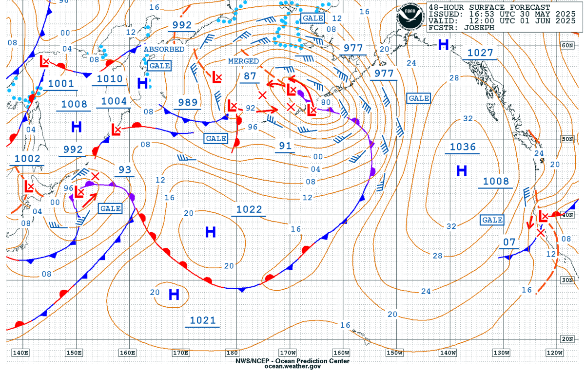
As you can see from today’s Surface Analysis Chart, we have a weak ridge of high pressure over the area with a trough of low pressure on the other side of the Cascades. Offshore, a pair of weak cold fronts will move over the area tomorrow morning, with strong high pressure quickly developing behind them. This will bring strong westerly winds down the Strait of JdF and the Strait of Georgia. You can see these fronts in today’s Sat Pic and the wind reports from the Strait of Georgia and the western side of Vancouver Island are showing a very nice pre-frontal SE breeze.

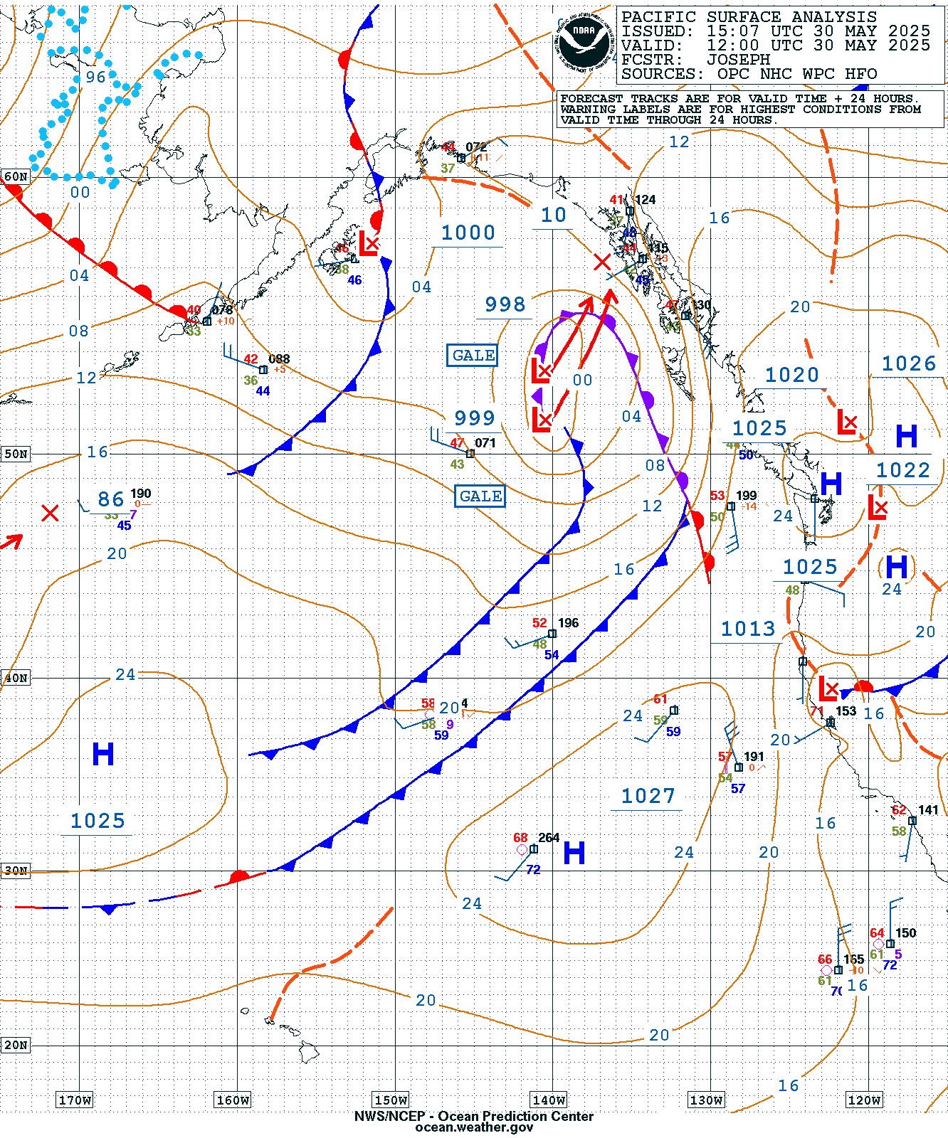
30 May Surf Analysis and 30 May sat Pic.
Then there are the breeze reports from the north end of Vancouver Island. How about SE 46 knots with higher gusts at the Brooks Peninsula, SE 38 at Cape Scott, and SE 30+ at East Dellwood, Sea Otter, and Herbert Island. The Van Isle boats are hoping that this won’t be there when they get to the legs going down the outside of Vancouver Island. The race course from Nanaimo to Campbell River has 15-20 knots of SE. This is not going to last as this front will move rapidly to the east bringing in the west-northwest breeze.
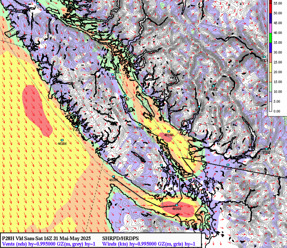
31 May 0900 HRDPS Chart
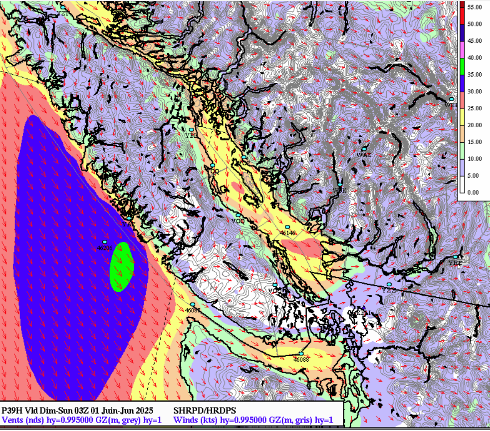
As usual, the models are not in agreement about how much and when this will fill; however, it does appear that you should have 10-25 knots of NW breeze for the start. As you sail north, the breeze will ease slightly as you sail between Lasqueti Island and Parksville.
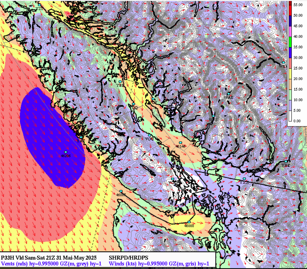
31 May 1400 HRDPS Chart
Remember that the breeze in that part of the Strait of Georgia is topographically forced so as you sail past Lasqueti the breeze will tend to clock from the NW to the N. The finish line is in Deep Bay so don’t overstand the approach to the finish if you’re on starboard tack from Lasqueti.
31 May 1700 HRDPS Chart
As you approach the finish in Deep Bay, the breeze will ease substantially as you get close to the finish. Shift gears aggressively as you get in there.
Note also on the 1700 HRDPS Chart the area off of Tofino on the West Coast of Vancouver Island. The wind is cranking out there, steady 35-40 knots from the NW with higher gusts.
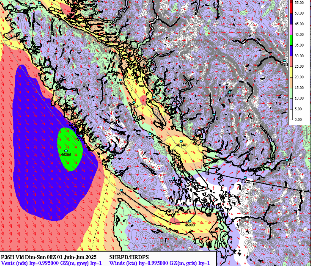
31 May 2000 HRDPS Chart
On Sunday, the 1st of June, you’ll race from Comox to Campbell River, which, from a tidal current perspective, is one of the most interesting places in this race because this is where the tides meet. Flood tides primarily meet in the waters between Comox and Campbell River. Specifically, the flood tide flows north from the south end of Vancouver Island and south from the north end of the Island, meeting in the area south of Mitlenatch Island. This means that in the Campbell River area, the flood tide is a southerly flow, while from Courtenay and south, the flood tide is northerly.
This means that for the day, you will have tide with you for the approach to Campbell River. Just be sure to arrive before approximately 1500 hours, when the tide will turn against you.
This could be challenging, as there will be slightly less wind than on the first day, with the breeze remaining in the 8-12 knot range from the NW.
June 0500 Surface forecast chart
This can be a tricky leg with this wind direction. In the past, it has paid to stay to the west of the rhumbline, especially if the breeze comes down from Campbell River in pulses. The Vancouver Island side gets the breeze first.
Have a great race, stay safe, and enjoy this fantastic experience.
From Jay: Bruce Hedrick has supported sailboat racing in the Puget Sound for as long as we can remember. I talk with many of you that look forward to his weather forecasts, and have stories about sailing with Bruce. I am going to compile a list of your feedback about Bruce and his great contribution to our community — so if you have something to share, email me a your thank you to Bruce, an anecdote, a picture, and/or a story at jaycleon@yachtracing.tv.
Thank you. (and Bruce had nothing to do with this idea)