
Bruce’s Weather Forecast - Swiftsure 2025
If you’re an American and you were worried about how you would be treated in Canada now, don’t worry. We’ve made two trips up here in the last three weeks, and they (Customs, wait people, hotel clerks, and fellow sailors) are their usual more than friendly selves. They can’t help but be nice, even though we have not been the best of neighbors.
As usual, Swiftsure is always a challenge regarding forecasting, and this year is no different. The models are not in agreement, which is not unusual. However, the two models are vastly different, making sailors smile with reasonable times around the course and winds in the 10-20 knot range. The other three models start off very light until about 1400 hrs, when a reasonable westerly finally fills down the Straits.
This gets us to the problem, and that is the tidal currents. See below:
Tidal Currents at Race Passage
24 May
0839 Slack
1117 Max Fld 4.7 knts
1442 Slack
1732 Max Ebb 3.5 knts
2053 Slack
2320 Max Fld 2.8 knts
25 May
0123 Slack
0502 Max Ebb 6.0 knts
0917 Slack
1203 Max Fld 5.5 knts
1536 Slack
1846 Max Ebb 3.8 knts
If the wind is under five knots and you’re trying to beat into a 4.7 knot flood tide, that will be tough. If you are an ultralight with non-overlapping headsails, you can short tack the beach and make progress. If you’re a bit on the heavy side of displacement with 155% overlapping headsails, you may have to consider going outside Race Passage, which, while it is a longer distance, the current will be less than 50% of what it is in Race Passage. Game time decision.
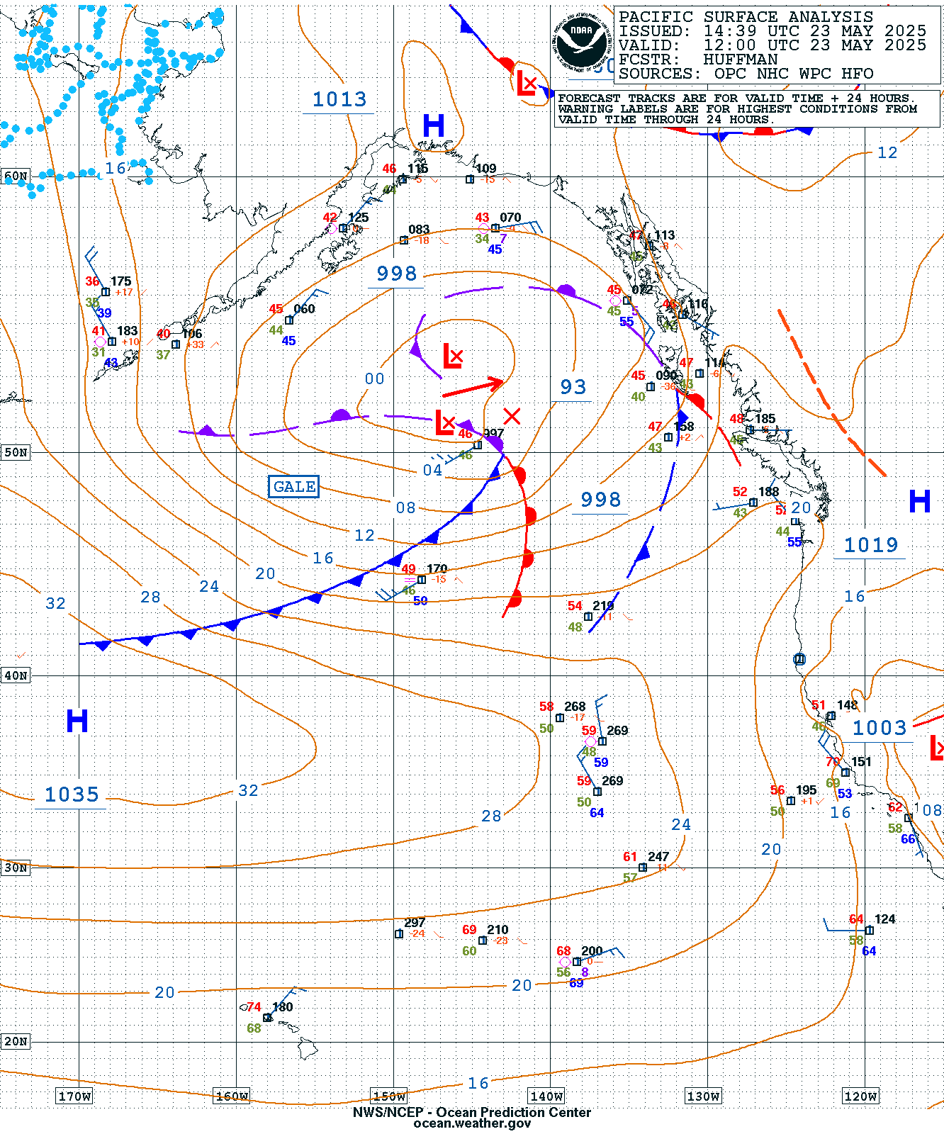
Overall, the Pacific High has still not set up properly. It is south of where it should be, flattened in shape, and has a lobe extending into the Pacific Northwest. Note the spacing of the isobars over the Pacific NW. We also have the remains of a cold front dissipating as it approaches the coast with another weak low-pressure system behind it. Both of which are visible on today’s Sat Pic.

The Saturday 0500 Surface Frcst Chart again shows quite a gap over the Pacific NW with the low in the Gulf of Alaska moving to the NNW.
24 May 0500 Surf Frcst Chart.
The Saturday 1700 Surf Forecast Chart shows the cold front approaching the coast; however, there is still a minimal pressure gradient over the area.
24 May 1700 Surf Frcst Chart.
The Sunday 0500 Surf Frcst chart shows the gradient tightening; however, as the front approaches, the offshore breeze will now come around to a pre-frontal SE.
25 May 0500 Surf Frcst Chart.
What do the different models look like, and what does that mean for the breeze? As is normal, the breeze in the starting area will be out of the SW and if you’re going to try and go through Race Passage you will want to get over to Albert Head area so you can get out of the flood and take advantage of the starboard tack lifting puffs as you get closer to the Race. Once you are through the Race, you will want to stay on starboard and aim towards the US side. After the Race, you don’t want to sail below about 48 16N until you are west of 123 50 because there will be less wind. After that, the breeze should clock from the W to the WNW and then to the NW.
All models agree that west of Cape Flattery, it will be light as that will be the transition zone from the NW breeze to the pre-frontal SE. For the Cape Flattery and Clallam Bay fleets expect a nice run back to the barn. With the caveat that if the breeze starts to ease after about 0200hrs Sunday morning, get to the beach on Vancouver Island because a whopping big ebb (6 knts) will be coming out of the Race at 0500hrs and will stay strong until about 0730hrs.
The forecasts are only updated every six hours so if you want any easy way to get some idea what might be coming in the Straits, you need to log the barometric pressure in millibars at Forks and Bellingham. Let’s say the baro at Forks is 1028MB and Bellingham is 1026MB. Subtract the difference 1028-1026=2MB multiply x 10=20 knots of westerly in the Central to Eastern Straits. A rough calculation, but forecasts are only done every six hours, and the VHF baro pressure is updated roughly every hour. Remember that if the pressure is higher at Forks, the strongest westerly breeze will be from Sheringham to a line roughly from Hein Bank to Dungeness Spit.
If the pressure is higher in Bellingham, the strongest easterly breeze will be from Sombrio Pt to Carmanah. On Canadian Wx VHF, you can also log the wind strength and direction at Sheringham and Race Rocks. Remember that the westerly wind speed can quickly double from Sheringham to Race Rocks.
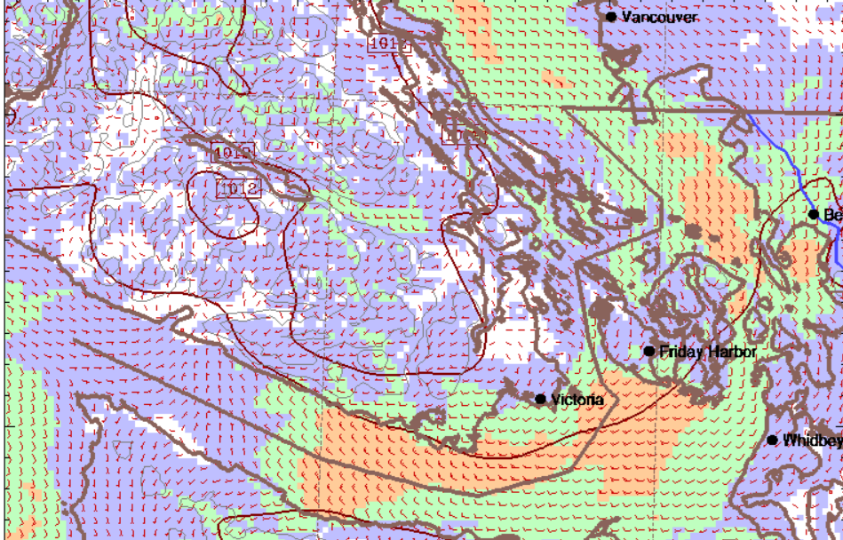
Below are the forecast charts in UW MM5 and HRDPS so you can get a feel for the difference.


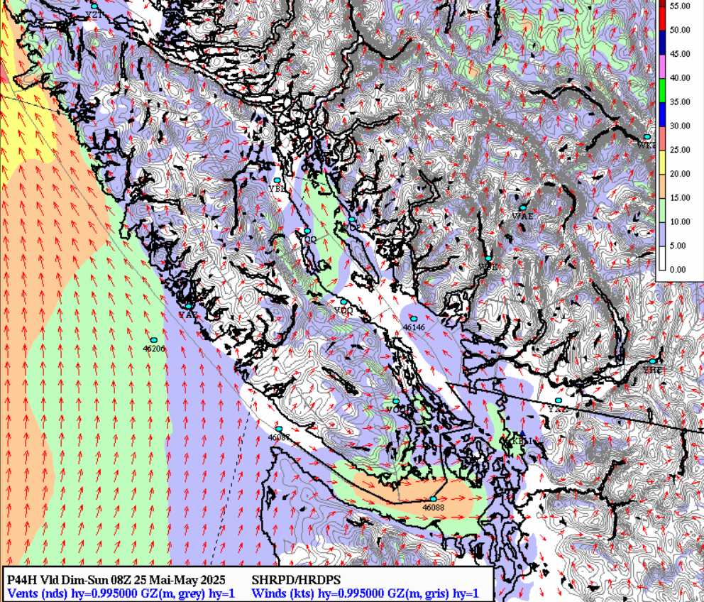
25 May HRDPS 0100hs

Have a great race, use your sunblock before you get to the boat, and be safe.
Follow the action on the Swiftsure page here.